Why is it drier east of the Western Ghats during the southwest monsoon?
Moist air from the Arabian Sea rises along the western slopes and cools, producing rain. Beyond the crest, descending air warms; the Deccan interior gets less rain from this monsoon branch.

Why India Looks This Way
On 14 October 2026, the India Meteorological Department forecast that conditions were becoming favourable for further withdrawal of the southwest monsoon and for northeast-monsoon rains to begin over the southern peninsula on 15 October. As the southwest-monsoon season winds down, why does the land east of the Western Ghats usually get much less rain from the southwest monsoon than the western coast?
Where does the summer rain meet the hills?
The Western Ghats run close to India's western coast, with the Deccan plateau stretching inland to their east. During the southwest monsoon, one branch of rain-bearing wind comes from the Arabian Sea. It reaches the coastal plain first, then meets the western face of the hills. NCERT's climate chapter describes this Arabian Sea branch and the contrast on either side of the range.
The air carries water as invisible vapour. To pass the hills, it rises, expands and cools. Some vapour then condenses into cloud droplets that can grow into rain. The slope facing the incoming wind is the windward side. The western slopes and nearby coast consequently receive particularly heavy rain from this branch of the monsoon. NCERT and the US National Ocean Service explain the mountain-rain mechanism.
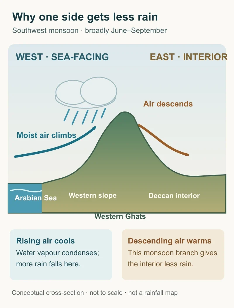
Diagram by BharatQuests. Conceptual west-to-east cross-section; not to scale or a measured rainfall map. Broadly shows the Arabian Sea branch of the southwest monsoon. Source: NCERT.
Why does the other side receive less?
Some air continues across the crest. It descends toward the plateau and warms. Warmer air can hold more water vapour before droplets form, so this descending flow is less likely to make rain clouds than the rising flow on the western side. The air also has less moisture available after some has fallen as rain. The drier area downwind is called a rain shadow. That name describes a tendency in this seasonal flow, not a sharp line on the ground.
The hills' position near the coast puts the steep climb directly in the path of the Arabian Sea branch. Rainfall still varies east of the crest: winds, terrain and other weather systems affect places across the plateau differently. NCERT describes the descending, warming air and the lower-rainfall area east of the Ghats.
What does that difference mean for people?
In its 2011–12 groundwater assessment, Maharashtra placed its central drought-prone belt in a 400–700 mm annual rainfall zone. The same assessment said that area contained about two-thirds of the state's irrigation wells. Both figures describe broad regional conditions in an older assessment, not rainfall in any particular village this October.
When rainfall is lower or less dependable, storing wet-season water and drawing on groundwater can become more important for farms. Whether that water lasts also depends on the local rock, how much rain enters the ground, surface-water supplies and the amount people withdraw. A rain shadow helps explain the starting rainfall pattern; it does not decide every well level or harvest.
“Rain shadow” does not mean the eastern side never gets rain. The Bay of Bengal branch and other weather systems can bring rain inland, with the mix changing by place and season. The Ghats explain a broad southwest-monsoon contrast, not the rainfall in every place on every day.