Why is western Rajasthan so dry?
Jaisalmer receives far less rain than Jaipur. The monsoon's route and the Aravalli hills help explain why.

Why India Looks This Way
At Jaisalmer, the India Meteorological Department's 1991–2020 record gives a mean annual rainfall of 236.9 mm. Jaipur's is 600.3 mm. These are measurements at individual stations, but they show why it is misleading to call all of Rajasthan equally dry. The long-term figures come from IMD's Jaisalmer and Jaipur station tables.
Western Rajasthan's rainfall depends on how monsoon winds approach the Aravalli hills and how often rain-bearing systems travel west. Sand is part of the landscape, but it cannot by itself explain where the rain falls.
Why does the monsoon drop less rain here?
Moist air can release rain as it rises and cools. A substantial mountain barrier across the path of a moist wind can force that rise. On India's west coast, the Western Ghats provide a clear example: the sea-facing slope gets heavy monsoon rain. In Rajasthan, the Aravallis run broadly from southwest to northeast. The Arabian Sea branch that reaches the state through Saurashtra and Kachchh travels largely along this alignment. There is no continuous, crosswise wall to force this branch upward as the Western Ghats do. NCERT describes this branch as giving scant rainfall along the Aravallis in western Rajasthan. NCERT, India: Physical Environment, Chapter 4.
That makes ‘Aravalli rain shadow’ a misleading shorthand. A classic rain shadow has a wet windward slope and a drier area beyond it. Here, the Arabian Sea branch runs roughly along the hills, so they force less of the moist air upward. The hills are one part of the explanation; they do not stop all rain.
Can rain also arrive from the Bay of Bengal?
The Bay of Bengal branch moves westward across the northern plains. Low-pressure systems associated with that branch can bring rain as far as western Rajasthan, although their tracks and strength vary. This helps explain why a relatively dry long-term climate still has wet monsoon seasons. NCERT describes the branch's route; an IMD-published study examines rain in west Rajasthan associated with distant monsoon depressions.
NCERT's rainfall map puts most of western Rajasthan below 50 cm of average annual rain and much of eastern Rajasthan around 50–100 cm. That describes broad regions over many years, not the rainfall of every district in a particular season. NCERT's rainfall distribution.
Three stations show the difference
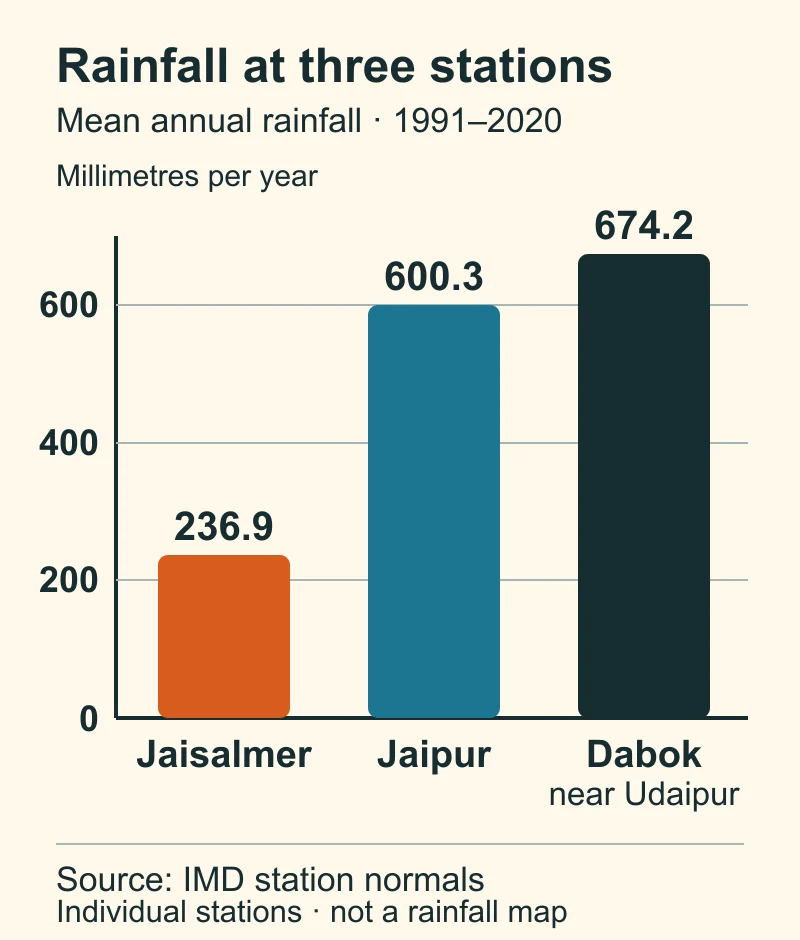
Mean annual rainfall at three individual IMD stations, 1991–2020; the chart is not a rainfall map. Sources: Jaisalmer, Jaipur and Dabok, near Udaipur.
Jaisalmer's mean is less than half Jaipur's; Dabok, near Udaipur, is wetter still. These three stations put a scale on the regional contrast, but they cannot map rainfall at every place between them.
What does that mean for people?
Limited and variable rain shapes the crops people plant and how they store water. Rajasthan's 2023–24 Economic Review lists bajra and moth among crops of its arid western plain, while distinguishing an irrigated northwestern plain. The state's Forest Department manual describes traditional rainwater-storage structures in western Rajasthan, including around Jaisalmer. These examples show why farms across the region have different water options.