What is a western disturbance, and why can it bring rain to northern India?
A disturbance in winds high above the ground can lift moist air as it moves east. Its path, moisture and temperature help determine where northern India gets rain or mountain snow.

Why India Looks This Way
On 15 October 2026, the India Meteorological Department identified a western disturbance near north Punjab and forecast rain across parts of north India. It also identified a separate circulation near south Haryana. Later that afternoon, The Indian Express reported rain in parts of Delhi. Why can a weather system from the west bring rain to the northern plains after the southwest monsoon has withdrawn?
What is a western disturbance?
High above the ground, fast winds called the westerlies blow from west to east. A dip in that flow, called a trough, can travel toward Pakistan and northern India, sometimes with a circulation lower down. That travelling change is the disturbance; western describes its usual direction of arrival. IMD's explainer and a 2025 scientific review describe this pattern.
The southwest monsoon brings moist seasonal winds from the ocean across much of India. A western disturbance is a separate weather system: northern India can still receive rain from one after the monsoon withdraws.
How can it make rain or snow?
Ahead of a western disturbance, air can rise over a broad area. If the lower air holds enough moisture, the rising air expands and cools. Water vapour condenses into clouds, where droplets or ice crystals can grow and fall as precipitation. The Himalayas can add to the lift as air meets their slopes. The scientific review describes both the broad rise ahead of the disturbance and the stronger rise against the mountains.
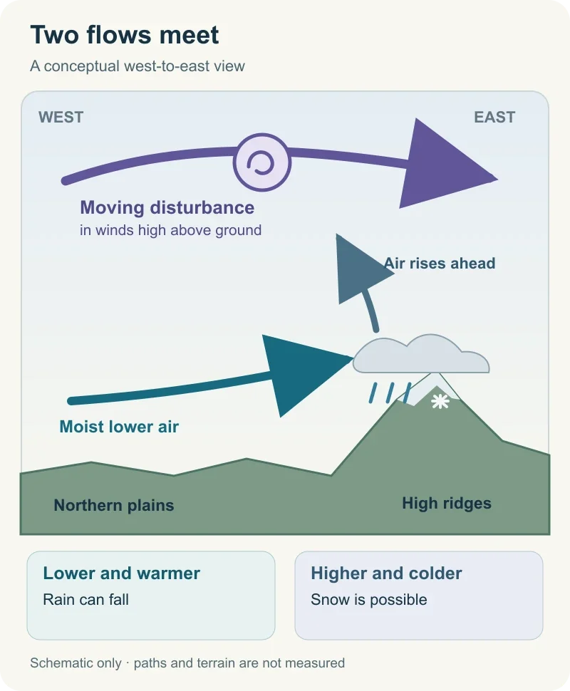
Diagram by BharatQuests. A conceptual explanation, not the 15 October storm track or a measured forecast map. Rain or snow depends on moisture, height and temperature. Sources: IMD and Hunt and colleagues.
On the lower, warmer plains, that precipitation can fall as rain. Higher up, if the air is cold enough, it can fall as snow. Neither outcome is guaranteed at every place beneath the passing system: its path, the available moisture and the terrain all matter.
Does the water come all the way from the west?
The direction the weather system travels and the source of the moisture that becomes rain are different questions. Western disturbances can develop far to the west, including around the Mediterranean and west Asian region, before moving east. The moist air they lift may come from nearer waters. In the scientific review's schematic, southerly air brings moisture from the Arabian Sea toward the western Himalayas as an upper disturbance approaches. This shows a possible route for moisture; it does not trace the water in Delhi's 15 October rain.
Are western disturbances limited to winter?
Western disturbances occur most often in winter, though the October bulletin shows that they can arrive in other seasons. Their effects vary from one passage to the next: one may bring welcome showers, while another has little moisture to work with or produces disruptive heavy rain or snow where it passes.
Winter rain can help rabi crops in the northern plains; NCERT's climate chapter describes that seasonal benefit. Snowfall in the western Himalayas can also add to mountain water storage, later feeding rivers as it melts, according to the scientific review. These are seasonal effects; the 15 October rain report does not establish a benefit to crops or mountain snowpack from this spell.
When a forecast mentions a western disturbance, the name alone cannot tell you where rain will fall. Its path and moisture supply matter, as does whether a place is a warm plain or a cold mountain slope. Together, those conditions explain why one northern area can get rain, a higher area can get snow and another can stay mostly dry.