Why do Himalayan rivers flow all year while many peninsular rivers shrink in summer?
The Ganga and Brahmaputra draw on melting snow and ice as well as rain, while peninsular rivers such as the Godavari depend mainly on seasonal rain. Gauge records show how far apart their dry seasons are.

Why India Looks This Way
On 15 October 2026 the India Meteorological Department (IMD) said the southwest monsoon had withdrawn from the entire country and that northeast monsoon rainfall activity had begun over Tamil Nadu, Puducherry and Karaikal, coastal Andhra Pradesh, Rayalaseema, south interior Karnataka and Kerala. On 16 October it said the wet spell with heavy falls was likely to continue over south peninsular India until 22 October. In the 24 hours to 8:30 am that day, Adayamadai in Kanyakumari district recorded 18 cm. That seasonal turn prompts a larger question: why do the Ganga and Brahmaputra keep flowing through the dry months, while many peninsular rivers, such as the Godavari, shrink to a fraction of their monsoon flow?
What keeps a river flowing in the dry season?
A river carries what its catchment, the land that drains into it, delivers. It arrives in three main ways: rain running off the ground, melt from snow and ice, and water that soaked into the ground earlier and seeps back out. Only the second and third can keep a river going when no rain is falling. NCERT's geography text calls a river perennial if it carries water all year, and non-perennial if it has very little water in the dry season.
Two different water supplies
NCERT describes the Himalayan drainage, which mainly includes the Ganga, Indus and Brahmaputra basins, as fed both by melting snow and by precipitation, and therefore perennial. It describes the peninsular rivers, such as the Mahanadi, Godavari and Krishna, as having non-perennial flow, and names the Narmada and Tapi, which flow through a rift valley, as exceptions. Peninsular rivers rise well below the snowline and have no glacier or snowfield to draw on, so their supply is rain and the groundwater that rain refills.
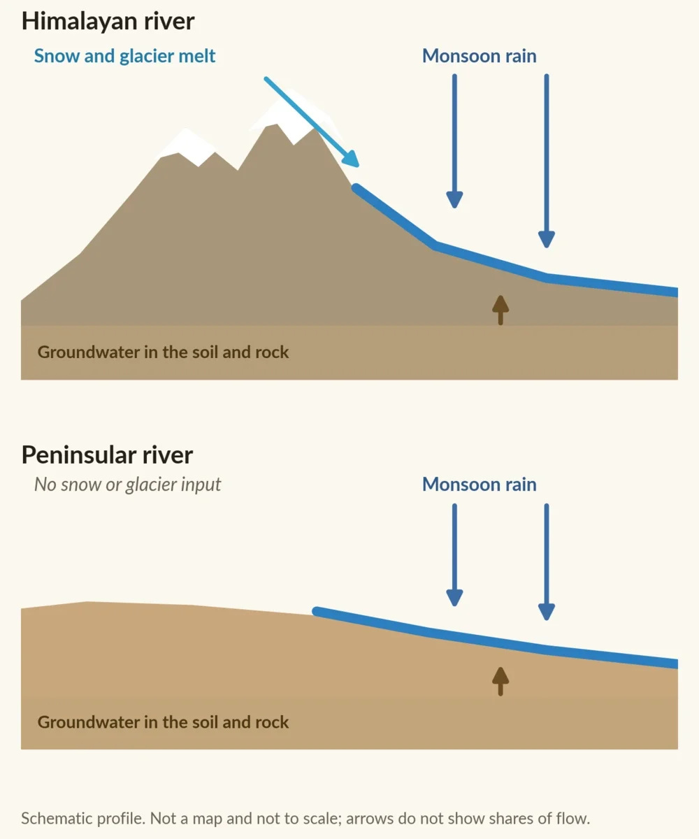
Schematic, not a map and not to scale. The arrows show where each kind of river gets its water, not how much comes from each source. Sources: NCERT, Drainage System. Diagram: BharatQuests.
Rain is the more concentrated supply. The southwest monsoon brings more than 75% of annual rainfall over most of the country, and a study of four large peninsular basins found that 58% to 90% of their rain falls in June to September. A river that depends on that rain has a few months of plenty and a long wait. Melting snow and ice add a second source that does not depend on the day's rain.
Glacier melt is a smaller part of the story than the phrase "Himalayan snow" suggests. A 2014 study in Nature Climate Change estimated that glacier melt made up about 41% of total runoff in the upper Indus basin but about 11.5% in the upper Ganges basin. These are modelled estimates for 1998 to 2007 of the runoff generated across each upper basin, not gauge measurements. The Ganga's water is a mix of sources, not glaciers alone. The gauge records below show how much higher the dry-season floor of Himalayan rivers is.
What the river gauges show
The numbers come from river gauges. A gauge station measures a river's discharge, the volume of water passing a point each second, in cubic metres per second (m³/s). One cubic metre is 1,000 litres, so 1,751 m³/s is about 1.75 million litres every second. The records below give the mean flow for each month at one station on each of three rivers.
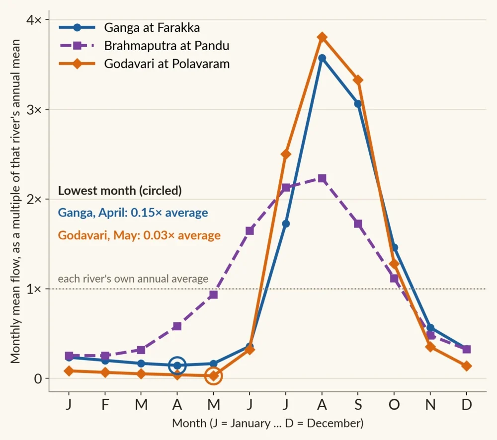
Monthly mean flow as a multiple of each river's own annual mean, so a value of 1× means that month equals the river's yearly average. Stations and years: Ganga at Farakka, 1949 to 1973; Brahmaputra at Pandu, 1956 to 1979; Godavari at Polavaram, 1901 to 1979. Data: Global Runoff Data Centre station records, as hosted by the University of New Hampshire's Composite Runoff site (Pandu, Polavaram). Chart: BharatQuests.
All three rivers peak in July to September, so both kinds of river have a wet season. The difference is in the lean months. At Farakka, in West Bengal, the Ganga's lowest month is April, at 1,751 m³/s. The Godavari's is May, at 87 m³/s, about one-twentieth as much. In April, the records show the Ganga carrying about 14 times as much water as the Godavari. The Ganga's catchment at Farakka is larger (about 935,000 km² against 299,000 km² at Polavaram), but size does not explain the gap: per square kilometre of catchment, the Ganga's April flow was still about 4.6 times the Godavari's.
| Month | Ganga at Farakka | Brahmaputra at Pandu | Godavari at Polavaram |
|---|---|---|---|
| Jan | 2,827.0 | 4,626.7 | 254.8 |
| Feb | 2,419.0 | 4,576.5 | 203.2 |
| Mar | 2,014.4 | 5,768.9 | 154.5 |
| Apr | 1,751.0 | 10,553.7 | 121.6 |
| May | 1,984.5 | 16,941.5 | 86.8 |
| Jun | 4,314.4 | 29,811.0 | 972.8 |
| Jul | 20,793.4 | 38,509.5 | 7,603.0 |
| Aug | 43,030.0 | 40,439.2 | 11,566.9 |
| Sep | 36,899.3 | 31,213.5 | 10,116.2 |
| Oct | 17,592.9 | 20,209.2 | 3,886.5 |
| Nov | 6,836.7 | 8,678.9 | 1,068.8 |
| Dec | 3,984.5 | 5,865.8 | 423.0 |
Monthly mean discharge in m³/s at the same stations and for the same years as the chart; Pandu's record runs to November 1979. Source: Global Runoff Data Centre station records via the University of New Hampshire Composite Runoff site, linked above.
The word "perennial" is easy to over-read. A Himalayan river does not flow at a constant volume: the Ganga at Farakka carried about 25 times as much water in its highest month, August, as in its lowest, April. The Brahmaputra at Pandu varied by about 9 times, and the Godavari at Polavaram by about 133 times. In these records, 73% of the Ganga's yearly water arrived in June to September, as did 64% of the Brahmaputra's and 83% of the Godavari's. The Himalayan rivers have a much higher floor, but they swing with the seasons too.
Why the Godavari swings so much
Most of the Godavari's water arrives while the southwest monsoon is delivering rain over its catchment, and little arrives when it is not. In the same four-basin study, the southernmost basin, the Kaveri (Cauvery), differs: October to December, the northeast monsoon months, contribute more of its flow than they do in the basins to the north.
The IMD's announcements mark the turns of that cycle. The southwest monsoon's withdrawal ends the season that dominates the Godavari's flow, while the northeast monsoon, which includes Chennai's October to December rains, gives the southern peninsula a second wet season. The withdrawal criteria and the shift in regime are explained separately.
What the old gauge records cannot say
The three records end in 1973 or 1979, and a river's dry-season flow today also depends on what people do with it. The same study notes numerous water retention structures built to support irrigation in the peninsular basins. A reservoir stores monsoon water and releases it later, which changes what a river carries in the dry months. The charts show how these rivers behaved in the decades the stations recorded, not how much water they carry below a dam now.
The comparison has exceptions. The Narmada and Tapi, which NCERT names as exceptions among the peninsular rivers, have their own explanation of why they flow west. In Rajasthan, NCERT describes the entire Luni river system as ephemeral, in a region with its own dry climate. The contrast here is between Himalayan rivers, which have snow and ice among their sources, and many peninsular rivers that rely mainly on seasonal rain.
Why the difference matters
NCERT puts the practical result plainly: India's rivers carry huge volumes of water, but it is unevenly distributed in time and space. Non-perennial rivers have very little water in the dry season, and in the rainy season much of their water flows to the sea. For a town or a farm, the question is when a river carries its water. A Himalayan river keeps a substantial flow even in its leanest month. A peninsular river's dry-season supply depends on how much of the monsoon's water is held in the ground or behind a dam for the months that follow.
Cover images: Alaknanda river in the Himalayan valley by Bhavabhuthi (November 2023) and Dried river in February as seen from Ghat by Kulspedia (February 2016), both licensed CC BY-SA 4.0 via Wikimedia Commons. Cropped and combined by BharatQuests; the combined image is shared under the same licence.

