Why do Cherrapunji and Mawsynram get so much rain?
Moist monsoon air from the Bay of Bengal crosses a flat plain, then hits a steep hill wall. The forced lift gives the Khasi Hills' southern slope roughly five times Shillong's rain.

Why India Looks This Way
Cherrapunji (officially Sohra) and Mawsynram sit about 15 km apart in Meghalaya's Khasi Hills, according to Kuttippurath et al. (2021). India Meteorological Department (IMD) averages reported by Business Standard put Cherrapunji at 11,359.4 mm of rain a year (1971-2020 average) and Mawsynram at 11,802.4 mm (1974-2022 average). Shillong, Meghalaya's capital on the same plateau, averages roughly 2,200 mm in 20th-century station records. Why do two small places collect roughly five times as much rain as a city nearby?
The short answer
Rain forms when moist air rises and cools. In summer, the southwest monsoon, India's seasonal rain-bearing wind system, pushes moist air from the Bay of Bengal north across the flat plains of Bangladesh. It then meets the steep southern edge of the Meghalaya plateau, which Prokop and Walanus describe in an EGU conference abstract as the first orographic (mountain-related) barrier for these monsoon winds on their way to the Himalayas. The air climbs the slope, cools and releases its water as rain. The heaviest rain falls on the side facing the wind, where Cherrapunji and Mawsynram stand.
Rainfall is measured in millimetres: 1 mm is a layer of water 1 mm deep, or 1 litre on every square metre of ground. So 11,000 mm a year is about 11,000 litres per square metre.
Where do Cherrapunji and Mawsynram sit?
The Meghalaya plateau lies north of Bangladesh. Sato (2013), a study in the American Meteorological Society's Monthly Weather Review, notes that the plateau is typically lower than 2,000 m, modest next to the Himalayas, yet the interaction between its terrain and the southerly monsoon flow is thought to be a primary cause of its heavy rain. Cherrapunji lies at the plateau's southern edge, near the India-Bangladesh border.
A terrain profile shows why that edge matters. Along 91.70°E, just west of Cherrapunji, ground elevation stays under about 20 m for tens of kilometres, then climbs about 1,200 m between 25.15°N and 25.25°N, a horizontal distance of about 11 km. The land then levels out at the plateau top.
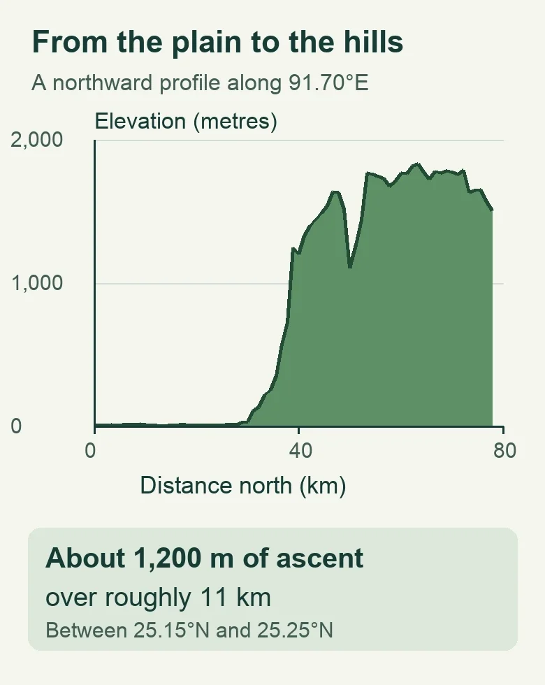
Chart by BharatQuests. Copernicus DEM GLO-90 elevations via Open-Meteo, along 91.70°E northward from 24.90°N. The vertical scale is exaggerated; the section runs west of Cherrapunji.
Produced using Copernicus WorldDEM™-90 © DLR e.V. 2010-2014 and © Airbus Defence and Space GmbH 2014-2018 provided under COPERNICUS by the European Union and ESA; all rights reserved.
Data notice: The organisations in charge of the Copernicus programme by law or by delegation do not incur any liability for any use of the Copernicus WorldDEM™-90.
How does a hill wall turn moist air into rain?
Warm air over the Bay of Bengal carries water as invisible vapour. When the air is pushed up a slope, it expands and cools, and some of the vapour condenses into cloud droplets that grow into rain. The side facing the wind is the windward side. Our Western Ghats article explains the same mechanism on India's west coast.
Sato's computer simulation of a June-July 2004 monsoon spell adds detail. When strong low-level southwesterly winds carried abundant moisture towards the southern slope of the plateau, the air was forced up and produced orographic rain. In the model's quieter periods, the low-level wind was too weak to lift air to the height where cloud forms. So the hills do not make rain on their own: the strength of the incoming wind decides how much falls. The study also found that these winds strengthen at night, and that rain peaks from the evening to early morning, matching satellite observations from the Tropical Rainfall Measuring Mission. In the model, the heaviest rainfall rates appear over the southern slope.
Why do nearby places get so much less?
The EGU abstract gives approximate annual means from 20th-century records: about 12,000 mm at Cherrapunji (around 1,300 m above sea level), 2,200 mm at Shillong (1,598 m) and 1,600 mm at Guwahati (54 m), north of the plateau in the Brahmaputra valley. Shillong stands higher than Cherrapunji, so height alone does not explain the rain. Position does: Cherrapunji sits on the slope that meets the moist flow, while Shillong lies back on the plateau top.
The same logic applies elsewhere: where a range lies across a moist wind, the windward side gets far more rain than the land behind it, as in the Western Ghats. For how the southwest monsoon winds down each autumn, see our monsoon withdrawal explainer.
Which place is the wettest?
Cherrapunji holds the best-known records. Guinness World Records lists 9,300 mm in July 1861, the most in a calendar month, and 26,461 mm between 1 August 1860 and 31 July 1861, the most in 12 months. Sato's paper cites the same 12-month figure.
Long-term averages depend on which years and gauges are used. A 2021 study in Environmental Research Letters by Kuttippurath and co-authors reports that Mawsynram overtook Cherrapunji by the late 1970s. For 1989-2010 it gives about 12,550 mm at Mawsynram (from the Meghalaya Planning Department) and about 11,963 mm at Cherrapunji. The IMD averages quoted at the start cover different periods and cannot be compared directly with those figures. Both places are among the wettest on Earth.
Single days can be extreme too. According to IMD data, Cherrapunji logged 1,563.3 mm on 16 June 1995 and 972 mm in the 24 hours to 8:30 am on 17 June 2022, the highest one-day June total since 1995 and the third highest in 122 years. On the same day, Mawsynram recorded 1,003.6 mm, beating its previous June record of 944.7 mm, set on 7 June 1966. As an illustration, 972 mm falling on a 100 m² roof in one day is 97,200 litres.
What does this mean for people?
Abundant rain does not guarantee water through the year. A March 2026 India Water Portal feature reports that residents of Cherrapunji buy water from tankers and that streams that once ran all year now stop flowing by winter. The feature points to rain arriving in short, intense bursts and to landscapes that no longer hold water.
Whether rainfall here is changing is debated. The EGU abstract found more days of extreme summer-monsoon rain in the second half of the 20th century, offset by a weaker winter monsoon, with no significant trend in annual mean rainfall over the Meghalaya Hills. The Environmental Research Letters study found no significant annual trend across northeast India for 1901-2019, and a positive but statistically non-significant trend at Cherrapunji. It also noted a steep decline at Cherrapunji and Shillong since the mid-1980s, and advised caution in interpreting those long-term estimates.
These annual totals describe how much rain falls, but not how evenly it arrives or how much water remains available through winter.
Cover photo: cloud over a forested hillside near Cherrapunji (Sohra), by Sumanjit100, taken 21 June 2012, CC BY-SA 4.0, via Wikimedia Commons; cropped.
